


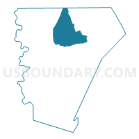
Voting District 0014, Burnet County, Texas
About
Outline

Summary
| Unique Area Identifier | 671234 |
| Name | Voting District 0014 |
| County | Burnet County |
| State | Texas |
| Area (square miles) | 78.58 |
| Land Area (square miles) | 78.41 |
| Water Area (square miles) | 0.17 |
| % of Land Area | 99.78 |
| % of Water Area | 0.22 |
| Latitude of the Internal Point | 30.91402790 |
| Longtitude of the Internal Point | -98.16423110 |
Maps

Graphs
Select a template below for downloading or customizing gragh for Voting District 0014, Burnet County, Texas


Neighbors
Neighoring Voting District (by Name) Neighboring Voting District on the Map
- Voting District 0002, Lampasas County, TX
- Voting District 0003, Burnet County, TX
- Voting District 0011, Burnet County, TX
- Voting District 0015, Burnet County, TX
- Voting District 0016, Burnet County, TX
- Voting District 0017, Burnet County, TX
Top 10 Neighboring County Subdivision (by Population) Neighboring County Subdivision on the Map
- Lampasas CCD, Lampasas County, TX (16,947)
- Burnet CCD, Burnet County, TX (14,643)
- Briggs CCD, Burnet County, TX (1,988)
Top 10 Neighboring Unified School District (by Population) Neighboring Unified School District on the Map
- Burnet Consolidated Independent School District, TX (22,039)
- Lampasas Independent School District, TX (19,241)
Top 10 Neighboring State Legislative District Lower Chamber (by Population) Neighboring State Legislative District Lower Chamber on the Map
Top 10 Neighboring State Legislative District Upper Chamber (by Population) Neighboring State Legislative District Upper Chamber on the Map
Top 10 Neighboring 111th Congressional District (by Population) Neighboring 111th Congressional District on the Map
Top 10 Neighboring Census Tract (by Population) Neighboring Census Tract on the Map
- Census Tract 9601, Burnet County, TX (5,731)
- Census Tract 9505, Lampasas County, TX (3,744)
- Census Tract 9602, Burnet County, TX (2,714)